GeoMapFish version 2.6

Yves Jacolin
GeoMapFish is a web-based, extensible and flexible GIS application with many features. It offers several interfaces: desktop, mobile, administration, and some more for specific purposes, as well as an API for integrating maps into third-party applications. Based on OGC standards, a GeoMapFish application makes it possible to broadcast spatial data in the form of services (WMS-T, WFS-T, WMTS) for desktop clients (QGIS or ArcGIS for example) or other web clients. On this base, cartographic business applications can be built.
GeoMapFish combines the best technological tools into one application:
- OpenLayers 6, AngularJS and Ngeo on the client side
- Pyramid-based Papyrus for the server framework
- MapServer, QGIS Server or GeoServer for map services
- PostgreSQL and PostGIS for data storage
- MapFish Print for printing cartographic documents in PDF or PNG format.
Presentation of new features
Interface
Authentication timeout handling
In some situations (use after a while, or restarted application, etc), the server authentication is lost, even if the user interface doesn't show it and that the services behind requiring login are not working anymore.
A message has been added to the login panel to inform the user that he is no longer connected, as shown on the following screenshot:

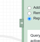
Resize right panel
Similar to the left panel, it is now possible to resize the right panel using the handle.
Search
Use of custom keyword as prefix for the layer search
We have added the possibility to choose a search keyword to get quicker results.
The key-word can be added to layers, layer groups, or themes, via the metadata "searchAlias" in the admin interface.
An example would be to have an "Electric power plant" using the alias "power" to get the result quicker.
Querying
Too many request messages on query
A message is displayed in the table result to inform that the results have been truncated as there are too many entries related to the chosen limit.

External WMS query
We allow the WMS getFeatureInfo to be queried on external WMS layers, so imported layers are now supported.
The result is shown in the pop-up or table query result window, similarly to the usual result queries.
CSV export in popup result window
In the popup query result window, the CSV export has been added and accessible using the "export" button.

Per-layer tolerance on query click
In this new GeoMapFish version, the tolerance per layer is settable. This is used when querying with left click.
Management of query scale on WMTS layers
Two new metadata are existing for WMTS layers to limit query results:
maxQueryResolution et MinQueryResolution.
Redlining tool and edit
Draw an arrow
The drawing tool supports arrows. This is an extension of the "line" tool.
The user chooses the direction and which segment the arrow has to be drawn to (if on a multi-segment line).


Edit overlapped geometries
The drawing tool is improved for selection of overlapping geometries and shows a drop-down list to choose the desired geometry.
On the following example, it is possible to select one of the two lines (both are fully overlapping):
Data check on field in edit form
When editing a geometry, and depending on the browser used, any type of data could be typed in a field. The "save" process would fail without warnings.
This was visible in example, on Firefox, when a user would type some text into a "number" field.
In this version, we added checks on the valid data type and the user is warned about which field has an error (if the browser originally doesn't prevent the invalid data in the field).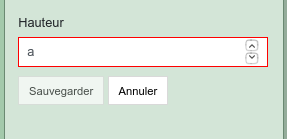
Element order in drop-down list
The drop-down list elements can be ordered with the addition of a new column "order".
When that is not existent, the default order is the same as in previous versions: the primary key in the database.
Data import
Display the imported layer legend
Previously, only legends from internal layers would be visible in the layer tree.
In 2.6, the imported layer legend is visible.
Drag & Drop files to show them on map
Instead of an external plugin, the drag and drop feature is supported to add the file content to the map.

Print:
legend display as a tree

The legend is now displayed as a tree similar to the structure of the left panel for a better readability.
On this picture, at left is 2.5
and
at right is 2.6 GeoMapFish.
Mapillary
Additionally, to the Google StreetView integration, GeoMapFish 2.6 has now a similar alternative, Mapillary.

Simple Application
We included a new feature called "simple application". The feature allows less customization, however it's a complete and simple cartographic solution, easier to deploy, maintain and build.
The following elements are customizable:
- The geoportal header
- The CSS variables (colors)
- Additional CSS rules
- UI components configuration
- Server configuration
- Of course: QGIS project, mapfiles and print templates
The other elements, as JavaScript, Python files, or the Webpack build are not modifiable and use the GeoMapFish standard.
It's worth to note that it is a first iteration and that we are going to improve over it in future releases.
Misc.
Permalink and sharing: timeslider/timepicker parameters
The permalink includes new parameters for timeslider/timepicker.
The permalink sharing supports this feature as well.
Measure and drawing: management of snapping feature
Snapping for measure and drawing is now usable in these tools as well.
Mobile: geolocation at application start-up
Geolocation at application start is possible for the mobile interface.
Administration interface
GetCapabilities synchronization to configure layer tree
OGC servers can be used to automatically import the layers it contains in the GetCapabilities query. This feature can also be used to resynchronize later if needed.
Various improvements in administration interface
Two changes are part of the new version in the administration interface.
Firstly, the restriction area page has a new "layers" sub-form. From there, the user can directly add or remove layers from the restriction area.

The second addition is in the role page. There, a list of users assigned to the role is visible, but it is only "read-only" and no modification is possible in the page.

For more information,
do not hesitate to get in contact with us!
Author
Career
Interested in working in an inspiring environment and joining our motivated and multicultural teams?
- Senior Infrastructure Engineer (m/f/d) - Zurich/Olten
- ERP Consultant Odoo Smartcamp (m/f/d) - France
- IT Project Manager (m/f/d) - Zurich/Olten
- GIS Technical Consultant (m/f/d) - Zurich/Olten
- ERP Consultant Odoo Smartcamp (m/f/d) - Zurich/Olten
- Odoo Developer Internship (m/f/d) - Chambéry
- Odoo Developer (m/f/d) - Olten/Zurich/Munich
- ERP Project Manager (m/f/d) - France


