SwitzerlandMobility WebMap now uses Vector Tiles for a faster map update

Elisabeth Leu
SwitzerlandMobility publishes thousands of routes for outdoor activities and coordinates the touristic information around it. For about two years, they have extended their offer of winter activities, publishing also snow hiking tours, snow shoe trails, cross-country skiing and sledging tracks.
Until recently, the webmap calculated these winter route networks as well as the summer routes by using WMTS image tile technology. WMTS is considered as the previous state-of-the-art technology for fast, geometry dense web-mapping. The calculation of the WMTS layers took considerable server resources and time, a temporary cloud server infrastructure was regularly mounted to generate new tilesets.
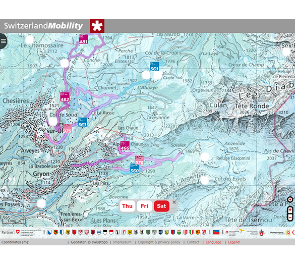
With the broader support of vector tiles, especially in PostGIS and OpenLayers, we now are using MVT format (Mapbox vector tiles) for publishing route data on https://map.schweizmobil.ch, making the user experience even faster and providing more up-to-date information for the end user. The data is now imported automatically into the PostGIS database, and the webmap consumes MVT directly from PostGIS, with an in-browser and Varnish Cache light caching. A speciality in this implementation is the projection and tile grid: despite the fact that MVT are normally in a world-wide projection, we chose the specific Swiss projection in order to keep the best visual result and be able to use different data sources as before.
The daily data update is especially useful for winter routes, which might change from day to day due to snow conditions and weather forecasts, or due to avalanche conditions which might force the staff on-site to change the route.

New features
Vector tiles open up a lot of other possibilities for new features, and by simplifying and speeding up the data management process, many new improvements in day-to-day data changes can be done now. In addition, we plan to improve the styling, allowing the user more flexible and client side adaptable styling. Stay tuned!

Route Information
… and by the way, by clicking on a winter route, you will now also see if the route is opened or closed, with a direct link to the snow report!
You would like to know more?
Please feel free to contact us.
Career
Interested in working in an inspiring environment and joining our motivated and multicultural teams?
- Senior Infrastructure Engineer (m/f/d) - Zurich/Olten
- ERP Consultant Odoo Smartcamp (m/f/d) - France
- IT Project Manager (m/f/d) - Zurich/Olten
- GIS Technical Consultant (m/f/d) - Zurich/Olten
- ERP Consultant Odoo Smartcamp (m/f/d) - Zurich/Olten
- Odoo Developer Internship (m/f/d) - Chambéry
- Odoo Developer (m/f/d) - Olten/Zurich/Munich
- ERP Project Manager (m/f/d) - France


