GeoVignes, a geographical module for vineyards and grape harvests

Yves Bolognini
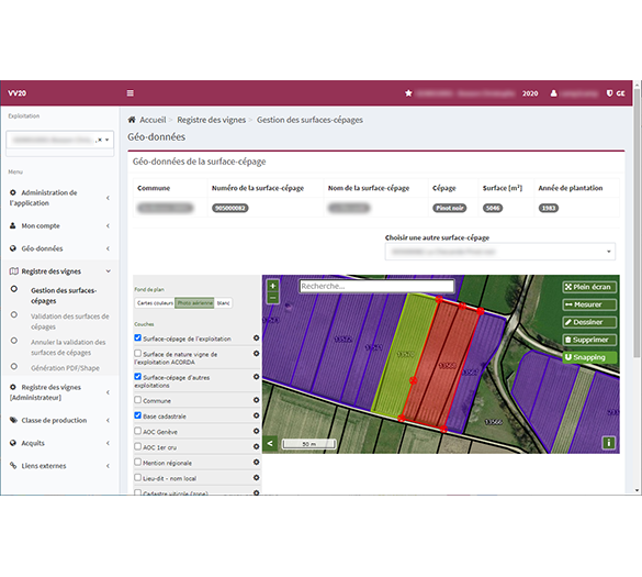
For several years, the Swiss Association for the Development of Agriculture and Rural Areas (AGRIDEA) has been working with Camptocamp to develop GIS based applications. The Acorda project enables farmers in the cantons of Vaud, Geneva, Neuchâtel and Jura to enter and share their farm data in order to benefit from the confederation's direct payments to which they are entitled. Successfully launched on 20 April this year, the Vines and Grapevines VV20 project has a similar objective for wine-growing data. Therefore, Camptocamp has created GeoVignes, a software that manages all the geographical aspects of this project.

The first users of the VV20 platform are the 1'800 wine growers in the canton of Vaud, for a total of 13'454 of vine-plots. In the geographical module integrated in the overall application, the user can enter polygons (using snapping on different base layers), be notified of possible overlaps, carry out searches, import or export geographical files and produce PDF reports. In addition to the APIs that represent the core of the application, the solution is completed by a number of batch services - a global generation of reports, list of intersections between parcels and data layers, a completion of data entered by calculation or retrieval of data from other layers (slopes, areas, communes, etc.). Further, all services provided are secure.
Data management and archiving also play an important role. Every year, the numerous data sets of the cantons and the involved confederation (i.e. Swisstopo) are updated, including amongst others: production sites, wine-growing regions, sloping land and vineyards. An annualisation system ensures the archiving of the data and the preparation of the following year without disturbing the entry of the current year.
For obvious reasons of efficiency and cost, the concepts of the Acorda project have quickly been adopted by the many users. In addition, GeoVignes is operated within the same IT infrastructure, which allows the application to benefit from the redundant architecture that has been put in place, thus also providing an excellent service availability.
For VV20, Camptocamp provides the GeoVignes geographical services, while AGRIDEA is responsible for the data entry via various interfaces, the link with the cantons and the coordination of the data entry campaigns. Thus, by combining both components all of the requirements for GIS data visualisation and data management could be successfully integrated.
Get in contact with us
Career
Interested in working in an inspiring environment and joining our motivated and multicultural teams?
- Senior Infrastructure Engineer (m/f/d) - Zurich/Olten
- ERP Consultant Odoo Smartcamp (m/f/d) - France
- IT Project Manager (m/f/d) - Zurich/Olten
- GIS Technical Consultant (m/f/d) - Zurich/Olten
- ERP Consultant Odoo Smartcamp (m/f/d) - Zurich/Olten
- Odoo Developer Internship (m/f/d) - Chambéry
- Odoo Developer (m/f/d) - Olten/Zurich/Munich
- ERP Project Manager (m/f/d) - France


